The Grand Tetons (Large Teats)

Day # 7 June 24, 2018  The destination for the next day was Twin Falls Idaho and clearly the best route was through Grand Teton National Park.  The most common explanation is that “Grand Teton” means “large teat” or “large nipple” in French, named by either French-Canadian or Iroquois members of an expedition led by Donald McKenzie of the North West Company.

The plains gradually gave way to multicolored and layered sandstones ridges and on up onto the Teton range and once again crossing the continental divide.  Since I have at least 3-4 pictures of me at sign post on the continental divide (me in picture with sign), I stopped to do my obligatory selfie.  In perusing through my picture I found a picture of the sign (I was not in it) and a picture of me with the divide area in the background (but no sign in it). I am trying to recollect what kind of disconnect I had there. 

Having backpacked and hiked there 4-5 years ago, as I gradually elevated into the Teton range I had a couple of very vivid memories. Today was a gorgeous day with a vivid blue sky and billowy cumulus clouds. On my first trip the extremely menacing massive violent black thunderheads and lightning and driving wind and rain blanketed the entire Teton Range, peaks and valley. I vice gripped the wheel and drove on through, very disappointed not to be setting foot in this NP.  The next trip was backpacking with my daughter Tasia, son-in-law Steve and granddaughter Amara.  We had some lovely sunny weather for a small option of this trip and some dry hiking, but our overnight at Bear Paw Lake involved hunkering down in our tents riding out the thunderstorms. The all night drizzle did no favors for one like myself who must exit the tent, cold rain and thunder storms aside, to pee and often with the damp and rain more than once. You haven’t really lived fully until you experience a  butt shower of cold rain in the middle of the night.  I had tried those female urinals to use in the tent previously and you might guess I ended up peeing all over my sleeping bag.  The storms weren’t as wild and intense as I experienced the first trip  but on a fair show and drenched us.

I was excited to re-visit theses ruggedly majestic massive escarpments dressed with lodgepole pine forests,  ice flows, snowpack and lakes – minus foothills but surrounded by sagebrush flats and wet meadows. Given the need to get out to Oregon, I didn’t take much time to explore the park this year but just meandering through in with my puppies in Lady Spitfire made my heart happy. It was a beautiful sunny day and how grateful I am to be able to revel in this beauty. Motoring on into trendy Jackson Hole brought on an entirely different feeling — with the throngs of people, expensive shops, enticements for extreme adventure and traffic jams. It felt like a rude welcome to a more realistic world of today’s day and age. 

Soon I was leaving Wyoming and on into Idaho. It was approaching dinner time and traveling with a diabetic dog requires some accommodation. So I off ramped into a truck stop and proceed to have them dine at the Spitfire Truck and Doggie Cafe, and arriving in Twin Falls around 8:30 PM. I make note of the time because I am usually the one to arrive earlier in the day and get the best parking spot to access my room.  I am always amazed to see the packed parking lot when I take the dogs out at night one last time. Now I was for a change one of the later arrivals.

Scotts Bluff and Fort Laramie in Mecheweamiing

Day # 6 June 23, 2018  Wyoming is a contraction of the Native American word mecheweamiing (“at the big plains”), On day #6 I headed up to Casper Wyoming via secondary roads as I had spotted on the map a national monument and national historic site in the direction I needed to head: Chimney Rock National Historic Site and Scott’s Bluff National Monument. Chimney Rock was a very well recognized landmark along the Oregon Trail. It’s an impressive  monolith, which in the early settlers more puritanical heritage was finally designated Chimney Rock, but I find euphemisms based on the original Native American name, such as Elk’s Peak and Elk Brick or perhaps even Elk’s Pxxxs (male phallus) more interesting.  I had hope to take a hike out towards the rock, but with no designated trails and signs abounding about “beware of rattlesnakes” I used caution (which I am not always prone to do)  and took head of the warning.

A few miles up the road  along the North Platte River is Scott’s Bluff an immense sandstone formation which is gradually eroding away grain by grain of sand.  However with a top that was protected by a cap stone, Scott’s Bluff has survived the erosion that wore away the surrounding structures and that created the Great Planes.

IMG_5392
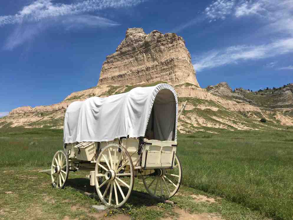
I was so grateful to find the trails here dog friendly and traversed both the South and North Overlook Trails and a brief section of the Original Oregon Trail. I must admit Kili and Simba enjoyed the Overlook Trails but did not have much enthusiasm for the original section of the Oregon trail here. Simba found great relief by the cow and both refused to walk any further.  Guess they were not born of pioneer blood.

I experience some level of nostalgia and fond remembrances of the old geography and history class, as well as movie and TV that brought to life much of the history of the pioneers and the tremendous challenges they faced. I had been complaining about the rather dowdy Motel 8 I stayed at and then on this day found myself feeling internally embarrassed as I viewed the exhibit of the Conestoga 10 x 4 canvased topped wagons and recalled the trials and hardships, rugged terrain and wildly unpredictable weather the pioneers faced right on this very land I was treading on. I am a whole lot heartier than many of my peers and love backpacking in the wilderness in most weather, but my REI, Patagonia, High Sierra, Jetboil and MSR Pocket Rocket make the challenge a luxury high end trek compared to plowing across country to make a better life in a rickety wagon or walking much of the way to lighten the load. 

IMG_5391

I was now firmly in the mode of visiting historic sites, I crossed into Wyoming and headed to Fort Laramie National Historic Site, a very stark and treeless setting and again conjured up visions of the Lakota (Sioux) trading buffalo robes and later the emigrants stopping over to re-supply on their westward journey via the Oregon Trail. Naturally I also felt outrage again at the treatment and mass murder and destruction of hunting grounds of the Native Americans as the emigrants swelled and began claiming the Lakota, Sioux and Arapahoe lands, fighting wars, executing treaties and then breaking them.

Moving onward through Wyoming I could not help but notice oil wells and surprisingly to me many long coal trains.

IMG_5413 My final stop was in Casper Wyoming, and another very dog friendly LaQuinta and of course the numerous tedious dog walking circles of the motel parking lot. 

Okla Humma to KaNze to Nebrathka

Day #5, June 22, 2018   The Choctaw phrase okla humma, literally means red people. It combines two Choctaw words, “okla” meaning person and “humma” meaning red to form the word . The Kansas, Omaha, Kaw, Osage and Dakota Sioux Indian word “KaNze” meanis, in the Kansas language, “south wind.”.  “Nebraska” is based on an Oto Indian word Nebrathka meaning “flat water” (referring to the Platte Rive,).  As this is he fifth cross country driving trip from Florida to Oregon,  it is always a challenge to determine a new and engaging route.  I opted to head up through central Kansas on secondary roads, avoiding Wichita Kansas and populated ares to the east.  I had conjured up images of Wild Bill Hickok, Wyatt Earp, the Chisholm Trail, and the wild western town of Dodge City of the TV westerns of my youth to keep myself amused. I was quite surprised to have my childhood impression of Kansas (being nothing but flat land with fields of corn and wheat) dispelled. There  was not much in the line of dramatic geological featured and there was a lot of flat land & wheat and corn fields but also lovely green and gold undulating terrain and numerous fields of other  crops.  I was also surprised to see oil and gas wells appear on the landscape.


The target was the night was North Platte, Nebraska given the amount of driving I wanted to do that day and the spare number of towns along the way.   I knew something “big” was going on in that area as I was hard pressed to get a motel reservation of any kind, let alone one that accepted dogs and had to settle for the Motel 8 in North Platte.  The place was packed and I discovered was in the midst of the attendees  of the 3 day music fest “Nebraskaland Days 2018  Summer Jam Music Festival.”  I new with 3.5 stars rating on trip advisor it wasn’t going to be top of the line even for a Motel 8 (which  find quite variable) but it was pretty clear that ratings are relative to what you expect and where else you usually stay? My room was adequate to sleep in but the decor conjured up images of leftover’s from Aunt Mabel’s attic of days of yore —  and well worn in every way. The real pain was the $150.00 I had to fork over due to the jacked up prices and dog fees.  It was hard to believe I  had paid $80.00 for a very new LaQuinta Room with 2 Queen Pillow Top Beds  the night before. (see entry  below or of previous day.) I felt like a sucker.

The Osage Nation

Day #4  June 21, 2018  A few weeks ago, the book club I belong to read “ Killers of the Flower Moon” by David Grann.  It chronicled the murders of numerous Osage Native Americans and the birth of the FBI. Very interesting read. The setting is in northeastern Oklahoma in Pawhuska, Grey Horse and Fairfax within the Osage Nation Reservation. It inspired me to drive through this area to have a keener sense of the setting that caused so much harm to the Osage. I  was enraged yet again about the malicious treatment of the people of this nation — driven from Kansas and given rocky land for their reservation which was not deemed particularly desirable by white settlers until the discovery of oil. In addition to the events in Osage Country  I was reminded of Standing Rock which made current news headlines the last couple of years  with Native Americans protesting their land being used for a pipeline. Some dynamics seem to never change with the total disregard of the Native American tribal rights and history. 

IMG_5303IMG_5310

Driving through Oklahoma was pleasurable, using secondary roads and the Indian Nation Turnpike, looping Tulsa and on into Osage County. The landscape was primarily faming — a combination of pastureland and fields of corn, cotton and hay — and dotted with oil and natural gas wells. The area is heavily dependent on oil to drive its economy. I found it fascinating to see the stretches of terrain being used simultaneously for cattle grazing, while dotted with oil  wells and wind farms. The downtown was shabby chic in my estimation and I enjoyed walking its main street. I also surprisingly observed many long freight trains of coal.  

IMG_5327


The town of Pawhuska has a classic main street with crumbing facades, eroding bricks, and peeling paint of buildings that have seen a richer history. I tried to picture Osage Mollie Burkhart, a resident of Grey Horse; Ernest Burkhart, Mollie’s caucasian husband; Ernest’s uncle, William Hale, whose business interests now dominated the county and who was revered as the “King of the Osage Hills” and Tom White was an old-style lawman assigned by the FBI to the murder cases — all walking the streets of this city.

IMG_5313


For me, Pahuska is a welcomed  break from the cloned environs of so many towns and cities — homogenized by corporate America with chain after chain after chain of carbon-copy stores and eating establishments. Guess I have already harped on this several times already…but I just can’t help myself in this day and age where there is a desire on the part of many to whitewash everything and bury forever the culture and uniqueness of the small town— all for the sake of big corporate profits. Where towns are  preserved and have a flavor of days gone by, usually through corporate investment, they  becomes trendy and unaffordable (i.e.Jackson Hole). For many I imagine there is a safety in that realm of sameness but I find it somewhat tragic that we have lost so many of the unique mom and pop businesses. I recollect traveling with a Work and Witness Missions Group in the Ukraine and the overwhelming majority of the members voted to eat at McDonalds in Kiev!!! Aargh! 

With the day waning, I opted for the LaQuinta in Panco Oklahoma, sandwiched between car dealerships and yet another xeroxed copy of the now classic USA Interstate Exit.  To be fair though, I did not get into he city so it may have a traditional main street downtown area. Ponca City is the headquarters of the Ponca Nation. Like the Osage the Ponca tribe was able to lease their land for oil exploration and development – land once deemed as marginal and used for the resettlement of native American tribes. This LaQuinta was quite new and sported their pillow top beds – which are very comfortable.  When asked how my stay was I said I only had one suggestion.  They needed to provide a step stool for short people like myself to be able to up onto the rather high bed more easily.