Driving the RV Highway to Iskut

OLYMPUS DIGITAL CAMERA

Thursday 26th

The alarm this morning was another train roaring “through” the park  at 4:50 .  It was a toasty 55 out this morning, though I still opted for the hoody. First morning dew of this trip making for a damp roll up of gear. Simba and I hung out all wrapped up in blanket and I played Candy Crush as I had no cell service. I actually am doing quite well without the latest politics revving my system up!   Today I was headed to Iskut and had a reservation at the Mt. Shadow RV Campground.  There did not appear to be any provincial parks at a reasonable distance so this was my first foray at one of those private RV parks. The driving goal was more modest at 328 miles. Having perused the map the previous evening, I could see the Rocky Mountains were to the east-though quite a distance and the Cariboo Mountains to the west. This gave me hope that the driving today would have much more differentiation in the form of peaks and valleys.  I was so enthralled as I began driving north to have the terrain become rugged, with jagged peaks, crevices with snow pack, barren summits and deeply forested faces.

I got my 3rd morning coffee, ice and gas in Smithers (7-11). The towns seemed to be getting smaller and smaller the farther north I drove.  At this point the Hazelton Mts. were to the West and the route crossed  the Skeena River.  I had been reading about several things in the Mileposts, the bible for traveling to Alaska, that gives extremely detailed accounts of every town, gas availability, location of litter barrels, rest areas etc.  Somehow I had expected to see big signs a la USA for the interesting things I had wanted to see but I was long out of town on the Cassiar Highway (37)  at Kitwanga before I realized there were no signs for the identified Totems, Hell’s Canyon Bridge  and other places of note I had thought about seeing. etc.  In contrast, that has also been one of the most refreshing aspect of today’s drive.  There are almost no advertisement billboards and signs.  

The towns now were few and far between. I gassed up at the Meziadin Gassbar as roads signs stated there would be no more gas for the next 65K.  This junction was the town:  one station, convenience store, cafe, and sani-dump. 

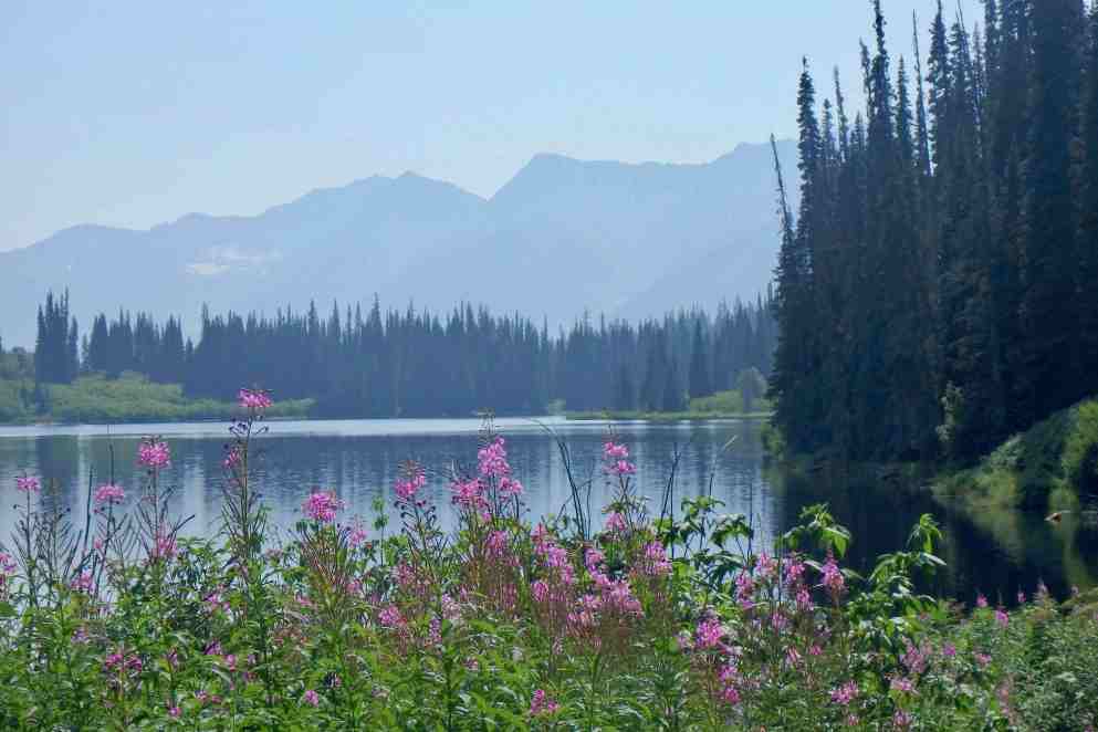
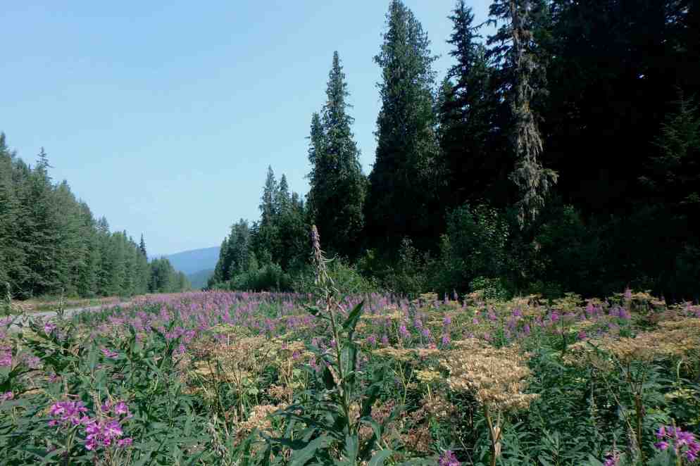
I was merrily on my way and excitedly realizing and that this was mostly rugged unpopulated territory and for much of it no power lines in sight.  The road was well maintained  and I drove for a couple hundred miles with minimal signage, the only signs being warnings to watch for caribou, bear, wildlife , cattle, and a few small signs when approaching a town.  I was heading into the Cassiar Mountains on a 2 lane, rolling and curving highway flanked  by towering lodgepole pine and shimmering aspen and again bordered with many  lacing of wildflowers.  There were also many bogs with their unique ill formed scraggly trees and the mountains were strong and grand and craggy and adorned with icy glacier fingers reaching down the slopes.  The highway crossed several rivers but I recall a couple which still had wooden decking and  Bell 1 and Bell 2 with metal grating with the  waters appearing icy cold and rushing.

Unfortunately, there still was a smokey haze put not a heavy as the previous day and the farther north I got the brighter it became.

I am glad i knew where I was going because there was no cell service the whole way – and besides I have a GPS in my car, though I usually use iMaps through CarPlay. The  further north I drove the road began to get narrower, with no shoulder and no center line.  It  was a lot of fun to drive as there was very little traffic and I could take the curves right down the  middle. I began observing the nature of the other vehicle on the road.  There were a few logging trucks and just a few other semis.  The rest of the traffic I was passing or oncoming was huge RV’s, large pickup trucks pulling RV’s,  smaller pick-up trucks pulling mini-RV’s, camper vans, trucks pulling boats, RV’s pulling cars, a few local trucks servicing the area, and almost no normal cars!!!,  That was quite a surprise but then there are few services, almost no sign of house etc. I mused that perhaps I had missed a sign that indicated that this highway was for local traffic or recreational vehicles only. 

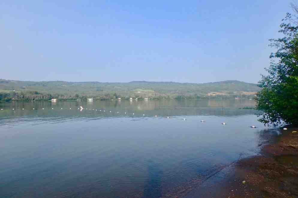
I decided to gas up at Iskut (a First Nation Community) before I headed to the resort.  It was was a very small community, the school appeared dingy and old, there was one convenience store and gas station. Kluauchon Center store,   I decided to buy ice  and took the last two bags which looked like they had been there a while and were in the bottom of the ice cream freezer. In retrospect I am glad I did because there was no ice to be had between Iskut and the Boyd Lake, my destination for the next day..  

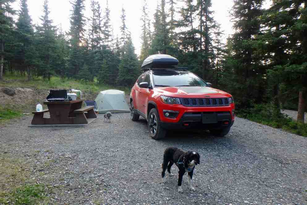
I head to Mt. Shadow RV Campground  I had driven by many that basically looked like an RV parking lot so I had a bit of trepidation. The online ads looked inviting.  It did turn out that the camping/tent spots were great. Shaded and clean (the RV area was like a parking lot, all lined up in 2 rows ). They advertised showers. wi-fi etc.  Turns out the showers were 2 loonies and you got 100MG of wi-fi or one hour whichever came first.  I decided to wait til morning for the wi-fi and text I wanted to sent to let family and friend know all was well.  So with camp set up and and dinner accomplished,  the boys and I took very lovely hike down to the head of Lake Kluachon Lake  It was quite swampy and not lake to dive into so here is yet another day that am continuing to ripen though wet wipes are helpful.  The dogs don’t complain.  

Vibrant Wildflowers, Lakes and Logging in British Columbia

OLYMPUS DIGITAL CAMERAWednesday  July 25th

My eyes popped open it turns out quite early that morning.  I awoke and it was quite light out so I was grateful that Simba had let me sleep in a bit.  I checked the watch and it was all of 5:00AM.   Seems I forgot how the farther north one goes in the summer the longer the days.  But having a close to 500 mile driving day,  I climbed out of the tent and discovered it was a chilly 49 degrees.  The good news was that the new tent sleeps warmer than old Coleman tent we inhabitated previously. 

Simba climbed out so I fussed with his breakfast and my coffee…after  quickly finding another layer of warm clothing.  I sat down to enjoy my coffee  and since there was no cell service, thus no access to the news of today’s political chaos agenda. That was good for a chilly  morning in the woods.  I could see that Simba, born and living in Florida for 14 year, was shivering even with his doggie coat on so I snuggled him close to me in my little backpackers chair. What a sweet sweet feeling it was out here in the semi-wilderness.  Kili popped himself out of the tent about a 1/2 hour later and turned right around and went back in.  He refused to come out until I dragged him out after I had broken down everything else down in the camp, including the tent fly.  By now I had settled Simba in the car with the heat going and KIli seemed to welcome that. But I was stalwart and didn’t cheat with car heat!! 

Once on the road it was a long day of relatively tedious driving, 477 miles from Big Bar Lake Provincial Park to Tyhee Lake Provincial Park. I was heading to Prince George via the Cariboo Highway (97); then north on the Yellowhead highway (16)  to Kilwanga and then up  the Cassiars Highway (37) to Tyhee Lake Provincial Park. The first challenge after getting on the road by 8:30, was to return to the highway via that 20 mile dusty gravel, washboard, cattle guarded road. The day was gray with everything again having a fine scrim through which to view the landscape.  It was a smoke haze caused by forest fires hundreds of mile afar. I was somewhat surprised by the landscape of the next few hundred miles. It has been a few decades since I studied geography and I doubt I learned anything specific about British Columbia terrain but I envisioned the entirety of my travels through British Columbia jam packed with awe inspiring rugged mountains and dense forests. I remember visiting Emerald Lake and Yoho National Park in the Rocky Mountains, in eastern British Columbia years ago.  However,  this route was quite in contrast to that recollection, with some lower peaked or rounded dome like mountains, hills, broad valleys, and the gray haze muting everything. It was quite hilly with moderate grades. Though the elevations of the mountains was about 2000-3000 feet above sea level, the mountains seemed  distant and nondescript. What was noticeable was large areas that have been infested by the pine bark beetle and there are massive stands of trees looking light ghostly skeletons.  They mostly target older Lodge Pole Pine and have devastated about 25% of the forestland which covers about 2/3rds of BC. The highway  continued to followed the Fraser River Valley.  There were  numerous lakes and many lovely views of Lac la Hache, an 11 mile long lake skirting the highway.  Another inserting natural feature are the basin bogs, swamps, marshlands  and lakes throughout.  The trees  are mostly sub alpine fur, Spruce, trembling Aspen, and Birch. The roadsides  were abloom with vibrant wildflowers creating quite a  breathtaking ride at times. I soon began to really appreciate the unique beauty of the forested hills, clear blue lakes, wetlands all flanked by an array of  magenta fireweed and purple and white lupine,  plus a variety of other white, yellow and red wildflowers

I stopped at 100 mile house (area an original post house on Cariboo Hwy) The name intrigued me, but the town really was not particularly unique. I was grateful for the 7-11’s big cups of coffee and of course gas and ice.  I had tried, on the previous day, to get coffee at  a couple non-familiar brand places and could not find  a big cup of coffee. So as much as I hate to use USA franchises when out of the country, I gave in and you can be sure they had the same big cups they have in USA. Happily on the  road, driving along it was clear that the major industry is forestry and you could see how it dominates the economy in Quesnel, with its massive lumber, pulp  and sawmills – and for miles either side huge piggy-back semis hauling logs. I skirted St. George and settled into making time and distance through a valley driven by forestry and agriculture and summer tourism, thus tailing both trucks laden with logs and hay bales and RV’s. 

I was grateful that all of the BC highways traveled  have a generous amount of passing lanes so I never got too antsy to make that pass at 80 miles per hour because there would be opportunities in 1-4 miles.  Another thing to really appreciate about these highways was the frequent turnouts, litter barrels, and rest areas with well maintained pit toilets.

OLYMPUS DIGITAL CAMERAI arrived at the campground by 6:00 after 470 miles, and managed to get set up and meals accomplished by 8:00.  The park is on Tyhee Lake and is clear and blue and a very swimmable temperature.  Since the dogs were not allowed on the beach, I opted not to go in, though I think I didn’t really want to so they became a good excuse.  I took  our usual nightly walk around the campground. The park service attendant came around selling wood so I bought a bundle and I opted for the first campfire of this trip.  I can’t say that it was particularly satisfying. The wood was hard and did not burn well, it smocked and smoked some more, giving all of my clothing the post campfire burnt wood stench and it put out minimal heat. Lots of work for little reward.  Around 10:40, just as I was settling in, I heard a distant train whistle.  But soon it was not quite do distant and then it felt and sounded like it was roaring through the campground. 

Flashing Lights, Construction & Gravel Roads in Scenic British Columbia

IMG_5978Tuesday July 23rd:  It seems as if I have lost my knack for a quick camp break down.  Of course I did choose to dawdled over my Starbucks Via and oatmeal — not exactly gourmet but on a sunny brisk 49 degree morning in the woods it was quite scrumptious.  Though awake by 5:15 we were not on the road until 8:45.  I wanted to stop by park information center and store but came to discover it did not open until 9:00 am. So it all worked out well since this was the only area in the park that had cell service and I could complete a couple of calls.   The drive out on Cascade Loop Highway was a rerun of the lovely drive going in and then it was onward north to the border and British Columbia!  I probably have used my speed control 90% of the time and been following the posted speed. When I checked my review mirror driving through the US border crossing towns of Lynden-Aldergrove, I saw those ominous flashing lights behind me –  so I pulled over and so do the flashing lights!!!  How ironic that I get pulled over for speeding the last day before I leave Florida, the east and southern embarkation point of my journey and just a couple of miles from home going 45 in a 30 mile zone AND here at the very border of this country in the western and northern most point before I cross into Canada, I get tagged for going 43 in a 25 mile zone. Now I have NOT changed my driving habits one iota so I would bet money that now that i am driving a bright orange Jeep, Lady Spitfire, I  am a clay pigeon for cops. In neither case did I get ticketed fortunately (I imagine they don’t expect to find a gray-haired 74-year-old lady driving such a flashy car!) The officer did admit that the speed charge was quite abrupt and though I was slowing down I clearly didn’t slam on the brakes fast enough.  So a few hundred yards ahead was the border and after all my fussing about getting the right rabies certificates for the dogs, the agent didn’t even bother to check them.  

I got on the TransCanada Highway 1 east at Abbotsford to Cache Creek.   Disappointingly,  the first part of the drive, could have been any place USA (or Canada) except for a few more Tim Horton signs at interchanges. It was a limited access 4 lanes highway up to Hope BC. I “towed the line” not knowing if there was any wiggle room before police officer will stop one for a ticketing in BC. Thank goodness my speedometer could be switched over to kmh. There I split off heading to Cache Creek. Before long I was sailing along at 110 KM (legal) and the scenery started popping, mile after mile through the Cascade Mountains. Many mountain peaks rose 2000-3000 meters above this two lane well maintained road, climbing and descending and rounding many curves— beginning with the Fraser River of Fraser Canyon.  Because of winter damage to so many of the roads, this day began the first of many delays for road repair. Fortunately none of delays lasted more than about 10 minutes.

The mountains seemed to have significantly more varying shades and appeared to be  based more of sandstone than the US Cascades.   As I drove farther north, the height of the range diminished and there was a wider valley and some minor peaks. The route followed the Fraser and Thompson rivers and I was quite taken aback when soon the vegetation in the area began to look more like desert with the temperatures in the low 90’s.  This is not the British Columbia I envisioned. This whole area was arid desert with sagebrush and other typical desert vegetation.  I later found out that Cache Creek had been described as the  Arizona of Canada with hot dry arid summers cold dry winters. I enjoyed the views of the Canadian Pacific and Canadian National Railway tracks and could see many trains snaking their way through this valley.

I traveled via British Columbia Hwy 97 north to Clinton and headed down a 20 mile gravel road to Big Bar Lake Campground.  I had made a campsite reservation without fully realizing the length of the gravel road. I soon realized after a bit of teeth jarring and fish-tailing, this road  would not allow the speeds of an asphalt  highway.  The anticipated arrival was  about 45 minutes later than I would have guesstimated. Try as I might to pick up the pace, it became harrowing on the curves and skiddish on the straight-a-ways, so I settled into the posted speed of 35mph give or take 10-15 mph faster. In fact I thought I did recklessly well by doing it in half-time.  I was extremely grateful that I do not wear dentures as I am sure they would have been  jarred loose on this washboard gravel road.

I thought I had a lake view campsite but the number I had written down was only a partial view (#12.)  It was not a bad site but after setting everything up and having dinner (and battling the pest of the day in the form of mosquitos) I came to find out that I took the wrong tent site (the one I had a very hard time finding) and indeed should have been on the best  lake side site.  As nice as it was it wasn’t’ worth the effort of moving tent and all the gear! A sunset walk by the lake was a peadful and soulful way to wind down this day. 

OLYMPUS DIGITAL CAMERA

I quickly found out that sometimes the good old-fashioned paper maps and a hard copy of reservations and itineraries etc. is a very good idea.   Since everything was on my computer and the documents only accessible through the Cloud from my iPhone or iPad, I was out of luck knowing where I should be when there was no service — which is most of the time in these nether regions I am traveling through.  Nevertheless despite no lake view we slept well!! 

Alaska Bound: From the Rogue Valley to North Cascades National Park

IMG_5954Day #1: It was time to begin the next leg of the moving to Oregon and Alaska  odyssey,  So on Sunday July 22 I headed out of the very smokey Rogue Valley of Southern Oregon with the final destination to be Soldatna Alaska.  I planned on taking 10 days to arrive there and to camp all but 2 of the nights.  IMG_5908 2 Adopting what I deemed a sound rational plan, I chose not to leave for the first night’s stay at the LaQuinta in Vancouver Washington until mid-afternoon. My first major stop was to be in the North Cascades National Park on Monday, to set up for the first day of this camping adventure through British Columbia and Yukon Territory. It had been 9 months since I pitched a tent and this one was new.  So I decided to get the repetitive driving routine section out of the way on Sunday, having traversed I-5 to Portland many times.  I wanted to  enjoy a brisk morning walk (it always dumbfounds me that it can be in the 50’s in the am and push upwards of 100 during the day on the east side of the Siskiyou’s in Ashland OR) and have more time with family.  So I finally got on the road by 2:30 in the afternoon for the five hour drive to north of Portland (which would of course be closer to six with gas and pee breaks and a stop to nourish and shoot up my diabetic dog). My logic would be less traffic and trucks on the road on Sunday.  That may have well been true if I could compare it to Monday, but traveling up the I-5 corridor through Oregon was no leisurely Sunday drive. Plenty of traffic, trucks and traffic jams.

IMG_5928Since the drive from Southern Oregon to and through Portland has been undertaken many times, it remained expedient to follow the path of the major highway designers, which is usually the path of least resistance — but also least interesting. The mountains of southern Oregon for first 100 miles are striking but the landscape was shrouded in smoke from the high number of forest fires in southern Oregon.  It was almost as if a scrim had been lifted at Exit 138 and I drove out of the smokey mist into blue sky and sunshine. I motored on through the relatively flat valley with not much ado and only had to start vice gripping the wheel when driving through Portland.  The traffic was fast (10 + over limit) with numerous tight curves and bridges.  Not much chance to even glance at Portlands modern city scape.  Portland is touted as a very desirable location and progressive city but it also comes with its expressways, traffic jams and many of the not so desirable features of a metropolis areas. Not far beyond was Vancouver WA and the bed for the night, arriving at 8:30 pm.

Day 2   Monday July 23:  Yesterday and this morning was the preface to this tale or perhaps the act before the main event but the journey finally really began when I exited the I-5 and headed up 535 to the North Cascades. Getting out of the motel was quite swift (had lots of practice last month crossing the country) but the surprise I awoke to was not so swift.  Crawling out of bed I noticed Kili sleeping on the other queen bed, something he never does. Looking a bit beyond the bed, there  was a pile of poop on the rug.  Poor guy had an accident and was probably disoriented  in he dark and got onto the wrong bed.  Clearly this dog does not travel well in some ways.  He had hijacked my quesadilla at lunch when I got up to get a club soda and it had onions on it – so I guess this was my “fault” for not guarding my food better from a dog who wants anything but real dog food!

By now you can pretty much guess my feelings and reactions to the  trip from Vancouver Washington  trough Seattle on I-5.  Traffic moves very fast and then barely moves at all – repeat TIME and time again. Siri keeps telling me which is the fastest route (I am not sure why Siri thinks I am always interested in the fastest route but then I guess she is not programed to be my personal assistant!) for a minute here or there really would not make a huge difference on this trip.  She actually advised that going trough Seattle on I-5 might be a minute or two faster than the eastern loop skirting around the city  So I figured crawling through Seattle would be a whole lot better than  crawling around the outskirts which I imagined would look like every other suburban interchange.  Besides, perhaps I cold catch a glimpse of the now ancient (but refurbished) Space Needle built for the 1962 World’s Fair.It was so famous when it opened and became an icon of the Pacific Northwest.  I was pretty shocked to find the road 5 lanes wide as in my mind Seattle was a sleepier town when I was last through there about 20 + years go…long before Starbuck’s AND Amazon were mega corps calling this city home.  In my mind, it is a huge modern city filled with shiny skyscrapers which now dwarf the iconic needle.  Somehow what does not fit in with my conception of the Pacific North West. 

I was finally delighted to be motoring down a narrow corridor of towering pine trees,  briefly interrupted by small towns and farms . Gratefully the traffic was light and we were at our campsite by 2:30 in North Cascades National Park. 

IMG_5930Setting up camp was relatively  smooth, new tent and all.  My Big Agnes Copper Spur – lightweight backpackers tent for three is just about perfect for 1 adult, two dogs a teddy bear and all of my STUFF – which of course I would not be needing if I was backpacking. I had a well shade spacious campsite in Newhalem campground loop C. There were definitely fewer tents that RV’s since these campgrounds do not have electric and water at the sites. Sadly there were many areas here and in the park that were hard hit by the mountain pine beetle and I observed a high level of tree mortality through out the area. I had read that it was impacting trees at higher and higher elevations as a result of global warming. The mountains sides appear ghostly with trees often still holding on to there needle, now gray and lifeless. 

 I decided to drive the highway through the Cascades  and the Ross Lake National Recreation Area. It was a hot July day (in the high 80’s) but It was  a lovely drive on route 20 and I was quite excited to be in the mountains with craggy peaks and the grandeur and majesty I was envisioning. One thing that was most noticeable was the massive hydroelectric projects and the resulting lakes and reservoirs. There were three major dams en route including the Gorge, Diablo and the Ross Dams. There were some beautiful views of the Ross Lake and Diablo Lake and the Sourdough Mountains – the shimmering lakes sported an electric turquoise hue offset by the deep green of the surrounding forests.

I was wondering if this would be yet another one of those dam building projects that, as a result of disrupting the natural flow of the rivers and  thus preventing  salmon and other species from reaching their spawning ground, might someday be the target of another one of the movement that is targeted tor dismantling to save species. 

Back at the campground,  forested with Western Red cedar, and Douglas fir trees, and near the Skagit River,  I began the challenge  of re-acquainting myself with all my camping equipment and food stuffs that I had packed weeks before-prior to the move from Florida and also managing the bees, mosquitoes and flies. It was mostly bees but they were not as noxious as I had anticipated upon their arrival.  They mostly sought moisture and as long as I minded my own business they did not bother this human that much. A quick dinner and nice walk around the campgrounds loop topped off the day.