Sequoia and Kings Canyon – A Day Trip

Having planned to stay in the area three nights, I had a whole day to spend relaxing. But a bit of “driving madness” took over and I decided that a day trip to Sequoia and Kings Canyon National Parks would be a great days outing. They were east across the San Joanquin Valley and it was a bright clear day. Of course this would also satisfy my bent on eventually visiting all the National Parks in the new few years. I thought I might “bag” a couple more and get the lay of the land and answer the question of whether I would want to return someday and backpack through them. I think some observers might say this has become an obsession of mine. Especially since this is no easy drive or straight shot across, but lots of hills and low-rise mountains to negotiate. There was fantastic scenery for most of the drive, but with stops etc., it took almost four hours.

My mood began to plunge as I could observe, the closer we got, a huge bank of clouds seemed to be settled in over the Sequoia National Park in the Sierra Nevadas. My hope was that it would be the early afternoon storms accumulating and they would dump their load and things would clear out. I stopped at the Foothills Visitors Center for mapsI took a some pictures at the first couple of pullouts in Sequoia National Park at around 2000 ft elevation and then began ascending about 5000 feet from the foothills, up the Generals Highway.


IMG_2960IMG_2965I hit a wall of fog that was dense and made for treacherous driving on this park road that was extremely winding and curving up the mountain. It probably can go without saying but I will say it anyway, I never saw any more of the canyon that I spent four hours getting too. One positive thing I can say about the fog is, it quelled my vista hopping and prevented me from taking 1000 pictures over the several mile drive.

The main positive experience was seeing the gargantuan Sequoias reaching for the heavens. I felt so diminutive in this grove of elders and was grateful to be able to take the Big Trees Trail through the Giant Forest and gaze at the General Sherman, the worlds largest living tree. As the weather was so miserable and cold, I felt ok leaving the dogs in the car for the 30 minutes. There is something so awe inspiring about these massive hulking stout giants – many of which have survived fires and everything else mother nature has shown at them. To me it would be an egregious crime to allow logging and cutting of these grand old guardian of the forest.


At the northern end of Sequoia National Park I had to make a decision . Should I be rational and turn left and head back to Pinnacles NP or should I choose the irrational and hope that by driving down into Kings Canyon, one of the deepest canyons in the US, the shroud of fog might be high enough that the lower reaches of the canyon would be visible. I bet on the absence of that gray scrim and that I might get a glimpse of the canyon walls. I new Kings Canyon also had some of the largest tree in the world. It was now 5 o’clock and I would have about 1 1/2 hours daylight for the 60 mile round d trip. I knew if I did not go I would be very disappointed in my self now that I was there so I headed east. The first stop was at the majestic General Grant sequoia, looming 267.4 feet up into the fog. It is noted as being the third largest living thing in the world. It was another giant ancient guardian of the forest . Then Another short but quite spiritual path circled this grove with numerous large relatives of the general residing. I was the road again and as I lost elevation and started going down, down, down the canyon, the walls began to appear and soon there were good views of the canyon and the South Fork of the Kings River.

I am sure with the sunlight to highlight its land forms it would be quite a bit more spectacular but with the grayness and the sky darkening, the walls seem lifeless and devoid of the lively shading and shadows created by the sunlight. But never-the-less it was a wonderful adventure and of course one that took until dark settled in to reach the bottom and the dead end of the road. So I had another exciting driving adventure coming out of the canyon on this very dark, relatively narrow winding and curving road. There was an occasional car on the road so I didn’t feel totally alone out there. By the time I reached the exit it was now 7:30 and I had minimally a three and a half hour drive back, if I took some interstates so I succumbed to expediency and the desire to be home by 11:00. It was Friday evening and a bit of a shock to pull into the campground, see a full sign, and then wind my way back to my campsite, seeing every site occupied. On the he previous 2 days I was there, it was probably only 20% occupied. I can’t say that it was noisy but there was a generalized low murmur of voices about. I missed the total quiet and solitude of the previous days.

Pinnacles National Park

Leaving family is never easy but it was time to head on back to Florida after being itinerant for 4 month and having logged almost 8000 miles of travel on an intensely active and varied journey. With a home sitting empty and several appointments on the November docket, I set out on Wednesday, October 18th. Though I had intended to leave a bit earlier, a trip to Oakland CA with my granddaughter Amara to visit my two granddaughters who live in Oakland took precedence. Since Amara wanted time with her cousins I chose to do the round trip from Ashland rather than going solo and heading on down through California with a visit en route. The plan was to return via a more southern route and hopefully avoid those cold nights in the tent I experienced in September last year when traveling through Lassen and Yosemite in California and Mesa Verde in Colorado. I had a two day frantic packing affair, including getting the car top carrier on; making decisions about which of my precious t-shirts I was going to leave and which to take (after all I really don’t need all 20 back in Florida where another 100 probably are rotting away in my absence); stocking up on camp food as if there were no stores along the way that i would come across on this journey (might this be called hoarding?); getting the car washed so it would look awesome on the dusty gravel roads I always manage to find; and most importantly getting to Starbucks for the Via!!! I then proceeded to poke my way out of town. I was at least an hour and fifteen minutes beyond my original goal. In most cases that would not make a difference, but I was heading to Pinnacles National Park and I did not relish the idea of setting up camp in the dark. Now I was pushing it.

I headed right back down the route I had followed on the week-end. My endeavor still is to avoid as many interstates as possible but there is no easy route through central CA that would get me there in any kind of timely fashion. Good old Siri suggested a couple of routes avoiding the interstate which would each take 12-13 hours. No thank you! I will tolerate the highway. The northern California selection of the drive from the state line through the Shasta Trinity National Forest and on down past Shasta Lake I must admit is scenic and lovely but once I hit Redding any semblance of enjoyment and appreciating the surroundings was a NOT! I all over again began to experience that hatred of Interstate with the fast moving cars darting in and out of traffic, the enormous number of enormous truck, the myriad of signs on very tall “stilts” so as to seen 5 miles back, the backsides of the small, medium and very large box stores, and fast food, and more fast food and gas, gas, gas! AND on this day there was a great pall of gray smaze/smoke hanging over the Coastal Ranges and Sierra Nevada Mountain Ranges on both side of the San Joaquin Valley. Some certainly was from the massive number of wildfires in CA. But the observing of it casted a very sombre tone to think that so much particulate matter from the cities, highways and farms affects so much of the grandeur of our country swell as plants, animals and humans

So I poked (well actually sped) on down Interstate 5 with pit stops just about every hour ( I had to speed to make up for these!) . I was trying to stay well hydrated and my body certainly was doing a great job of trying to dehydrate me. And of course there were the stops for three very short walks for the dogs. I was not in a patient place and by mid afternoon I knew I’d be setting up camp by headlight (assuming I could angle the car in a fashion to accomplish this. So i pathetically endured the drive but opted to head through Sacramento rather than back through Oakland. I hit my good old fashion and very endearing two lane roads at about the 400 mile mark. It took 400 miles of stress, smoke, piggy-back truckloads of garlic, back ups around cities, monotonous dry yellow fields of hay, etc, to get there.

IMG_2881

I still had about 90 miles to go but happily settled into a less frantic drive along the San Luis Reservoir and into the Diablo Range. Sunset was a panoply on pinks, purples and oranges and was very soothing and settling after the many tedious hours on the interstate. I managed to drive into Pinnacles around 7:30 and there was almost no ambient light so it was very dark and wonderful for star gazing. My car lights on bright however interrupted this dark space as the darkness didn’t make it easy to find the campsite, Somehow I had it in my head I was in campsite 86. The sign pointed to site 1-83 to the left and 84 + straight ahead. I could not find #86 and kept looping around feeling crazy while almost hitting two deer, dodging bunny rabbits, and shining my bright headlights into many campsites . All of the sites so far had signs on the primary road. Finally, after many turn arounds I decided to re-check my site number and came to discover it was 68, which had definitely passed at least thrice. Thank goodness it wasn’t 86 as the next morning i discovered it was in a loop of RV’S which appeared to be side-by side in a very open “parking” lot. Site 68 was very private, set in its own little “cul-de-sac with a long driveway leading into a nice little dining area and further in, past the bear box, was a partially fenced area for the tent surrounded by vegetation. I discovered in the morning the fence purposeful as without it I might have wandered out of the tent in the night and fell off a 15 foot ridge. It might also serve the very useful purpose of keeping deer and other critters from settling into our tent home.

it was not as challenging as I though setting upon the tent and all my luxury items since I was car camping . I could aim the car lights into the bedroom area and proceeded on. I decided to take a walk with the dogs to find a restroom and headed out to the right when I go to number 83 – the last one in this area with no luck I headed back and started out the other way. Of course it was not but 25 feet down from my site and set far enough back to not be noticed while driving my loopdy-loops. Since I was after hours there was no ranger handing out park maps. Interestingly this park seems to be on the honor system and at the entrance directs one to go to the information center and park store to pay fees,

I was under the impression that since I was close to 500 miles further south and not up in the high Sierra’s It would not be too chilly at night. I was expecting perhaps 50-55. I pretty much knew this was not the case as I settled into the tent and felt chilled. I actually had a couple of bouts of shivering in my sleeping bag, I checked the car thermostat in the morning said 39 degrees. With numb hands tried to open the S’Buck’s Via and light the Jet Boil. The canister was empty. Disaster was striking. Of course if this is the worst disaster I ever experience I am truly fortunate. I managed to get a new canister screwed on with my very numb fingers. Finally after all he fussing around I had a hot cup of coffee and was then willing to feed the dogs.who were of course cocooning in the tent and not silly enough to be out in the cold.

It was a lovely morning, though chilly, and after breakfast and a three mile walk around the campground, I decided to head over to the other side of the park SINCE THE DOGS ARE NOT WELCOME ON ANY OF THE HIKING TRAILS IN ANY NATIONAL PARK . The main road in the park does not go through so it is a 60 mile drive to get to the west entrance. I found the drive to be a great adventure as I was on a twisty, windy, hilly, dipping and twisting two lane highway with very little traffic. The scenery was varyingly beautiful and a clear sky provided excellent vistas of the near and distant mountains. The hills around were an array of domes, and at times peaks and pyramids, many extremely smooth and others dotted with chaparral and other scrub trees I kept imagining a great pile of gold, tan and brown velvet material having been laid upon this land and what resulted was graceful folds, curves, and shadows, on domes of many sizes. The road wove up and down like a roller coaster and at times I could see vast fields of vegetable in the valley below. At one pullout on a ridge above the valley I sighted a couple Condors soaring on the updrafts in the distance. This park is a release site for the condor which was listed as an endangered species. The rest of the time I am quite sure birds I saw of about the same size were turkey vultures! The beauty of backroads for me is that I feel so much more a part of the land. I can just pull off to the side and get an upfront and personal feel of the land around me, check out what is really growing that I had observed from a distance, and even touch the rich soils of these irrigated valleys. I don’t often see such vast fields of a variety of crops, all in different stages of growth. I was fascinated to be able to observe a field where busloads of pickers had been hired ,trucks with port-a-johns were on site, and hundreds of box loads of what appeared broccoli. This was so refreshing after the hundreds of miles of very arid bland cropland in central California. However, during along it was clear there is a lot of political controversy regarding water use and access. One sign I often spotted focused on the hypothetical question of “Is growing food a waste of water”.

CA 146, the road into the park was very narrow and winding and at times one lane. It is not a road for the faint heart. But that made it even more of an adventure and is fitting in this protected wilderness. Pinnacle National Park is one of the newest parks though it was a National Monument previously It became a park in 2013. Like so many of the parks it has a beauty all its own and the major landform from which it gets it name is a series of spires, ramparts and crags that are in direct contrast to the smooth golden rolling foothills in much of the park and surrounding area. The dogs and I were going to have a picnic lunch in the day use area just below the massive vault of spires but had to kept it brief as it was hot and full sun with no shaded tables to be found. So after appreciating the beauty of the spires which we were quite close and readily accessible (not so on east campground side), it was back on the roller coaster road home.

IMG_2935IMG_2936

“Home” becomes anyplace we decided to park our head for the night. I was relieved that this night was a toasty 46 degrees though there was a downpour in the middle of the night and everything was damp and wet. Fortunately I had not left much outside as this is bear country and things were either in the car or the bear box.

Brisbane – the final days of an Aussie Holiday

Brisbane, Australia’s third largest city has been described in travelogues as a “sub-tropical urban oasis“ and also as “the sunny, sophisticated capital city of Queensland.” I don’t think I can comment on the sophistication as I believe this would have required me to go to museums, art galleries, high end restaurants and perhaps a play or two. Those activities are not on my list of the top 4 things to do in a city. But I can vouch for it being sunny, sub-tropical and a very family friendly urban city with plenty of opportunities to play both downtown and in the suburbs of Wynnum, Manly, and Lota where my son lives. The final few days of my Aussie holiday were spent back in the Brisbane area at leisure while the rest of the family returned to work and other scheduled local activities.

Life was a bit lower keyed but it still had a lot of lively moments. I resumed my walking, either into town or on the bayshore, being mindful that I had signed up for a half marathon in Portland OR in10 days. I not only still had to step up my training miles but would be traveling halfway around the world, and would be needing to switch night and days around. I knew I could finish the course but I was more concerned about the pain factor should I blow off the final days of race walking. So my goal was to walk every day and include one 9-10 miler. For that I decided I would head to Lota Preserve to see if I could re-connect with the 8 foot python snake I met up close and personal a couple weeks previous. Not only did it stand me up, but Australia is heading into the summer season and the temperatures were climbing into the higher 80’s. I imagined reducing the discomfort in my feet from the long walk by soaking my feet towards the end in the pleasantly cold Wynnum wading pool. Being shallow however the water warms up fast so that the vision was quickly dashed. So I headed up into town and found a wonderful little coffee cafe to get a latte — and enjoyed it so much I returned there each day until I departed.

Public transportation is so accessible so Miriam, Luke and I headed into the city late one afternoon to meet Nick for dinner. We opted for both rail and river transit. We took the Queensland Rail into the city from Manly. Since I had never taken the CityCats, a catamaran ferry, on the river we opted for a “joy” ride since we had quite a bit of time before meeting Nick. Luke can identify the differences in the CityCats – from older to newer models in operation and insisted that I become proficient in this skill as well. Now in my mind the differences are subtle and difficult to commit to memories as this is not the type of information I normally choose to store in long term memory. But I worked at it as this is important to my grandson. More on this later.


Southbank was the destination on our “river cruise” but we got distracted and missed this stop. Much to Luke’s delight we could disembark and re-board a CityCat going the other way — and hopefully one of a different newer model. The distraction was the Australian Defence Force Army helicopters. They were practicing their routines for the “Riverfire” air show and fireworks display to be held on Saturday. They were flying low, hovering, and buzzing building and it made for a very exhilarating experience to witness. Once on shore, we wandered through the tropical gardens and by the man made inner-city beach of the parkland of Southbank with great views of the city. After spending some time at a playground for Luke we met Nick and the dinner choice settled on was “Julius Pizzeria” which to me is really a misnomer as it was not my ordinary concept of a pizzeria. It was a somewhat upscale restaurant. It was very busy though service was excellent with unruffled waiters; the menu had excellent variety of Italian offerings and many authentic thin crusted pizzas to choose from. The food was excellent.

I love the walkability of Wynnum – within a mile’s walk from the house, I can shop for just about everything I normally need. But one of the things I enjoy the most after the bay front is seeing the original Queenslander homes and in general the many homes resembling the architecture of the Queenslander homes. This style is very much the heritage of Brisbane. This style includes the raising of the main living spaces off the ground on vertical “stumps” of timber (we call them piles or stilts). This allows the building to “float” above the terrain. Stilt homes are typically build homes on stilts to prevent flooding. But in the original Queenslander, all have this underfloor area that is used to cool the building through ventilation as well as for protection from termite attack and other pests. Additionally, the design is both stylistic and practical and can overcome any variations in the terrain and allow for the flow of water across the terrain if rain excessive. The lower area is often screened around the base with wood strips.


This “stump” platform and the design and placement of the windows encouraged cross-ventilation and uninterrupted air flow for passive cooling. Nick and Miriam live in Queenslander and there is no air conditioning or heating, relying on the style of the home to regulate the cooling and heating of the home. It definitely is not the ideal solution in an age of air conditioning but I do like the eco-friendly and financially friendly aspect of it. As the breezes and fans don’t completely make for a comfortable temperature, I did opt for a space heater some nights. There is usually a verandah and it is a great outdoor living area and I really enjoyed their veranda with its mild breezes and shade. Though these homes are well suited for this sub-tropical climate, I noticed that more and more of the older homes and most likely all the new building have central air and heat and just use the architectural style.The roofs are usually steep and sheeted with corrugated metal. I also noticed walking through the neighborhoods that most of the homes in the areas I visited had front yard fences.

The grand finale of my visit in Brisbane was a family 2 hour sailing lesson and then a trip to the Brisbane Festival Riverfire for the evening festivities. Nick, Miriam and Luke are taking a series of 10 sailing lessons and wanted me to have the experience, so booked and extra outing so I could join them. It was great fun. I have never had much of a chance to sail so just learning such terms as main sail, boom, jib, keel, trim etc. was the first challenge. I had a chance to try several different positions but definitely my shot at managing the rudder was the most harrowing for everyone on board. Our instructor maintained control by straddling the rudder it and subtly (and then not so subtly) using his legs to prevent any catastrophic errors when I continued to forget to move the rudder in the correct direction or keep it centered. We arrived back at the dock though in good order without capsizing the boat.

We then journeyed from Manly Harbor, via Queensland rail, to the Brisbane downtown riverfront for the aerobics show of the Army helicopters and jets followed by the acclaimed Riverfire fireworks show. We again got to see the army helicopter display but of equal interest to Luke was the CityCat catamarans cruising the river. Each time one passed, and this was often, it was my job to identify which model it was. Fortunately I got a passing grade on this 3 hour quiz which occurred from our chosen vantage point on the not so easy on the derriere cement steps near the Riverside Center. We thought this a good vantage point from which we could see this ultimate array of pyrotechnics shooting from barges, pontoons, high-rise buildings, and the Story Bridge. We had a burrito picnic on the steps, people watched, and enjoyed being in the vibrant energy of this festival.The finale did not disappoint with an incredible 20 minute of blazing, booming, brilliant, sparkling, rainbow explosions. As we took the train home I felt sad that I would have to be leaving this lovely city, a wonderful country, and my dear dear son, grandson and daughter-in-law the next day. Our final outing on Sunday, departure day. was a trip to a Koala Reserve area, part of the property of the Nazarene Theological College.  It was a disappointment to not encounter any koalas there but I came upon the only kangaroo seen in the wild on the entire trip.

OLYMPUS DIGITAL CAMERA

OLYMPUS DIGITAL CAMERA

Ormiston Gorge – North MacDonnell Range National Park 

Not knowing if we would ever be coming back to the Red Center in Northern Territory Australia, we decided on one last very highly recommended area to visit — the West MacDonnell Ranges. This would be an approximately 550 K drive to the identified campground. Without a 4WD vehicle necessitated going back to Alice Springs and heading west to our destination which was Ellery Creek Big Hole Campground in Tjoritja /West MacDonnell Range National Park. It sounded especially inviting because it had one of the permanent water holes which we hoped to swim in. We anticipated getting there before dark, but barely. Since we had already seen the miles and miles of the stark and unremarkable bushland, we kept a good speed up and made decent time.

Since camping was first come first served, we had to consider alternatives as well since we would be arriving late in the day. We arrived there around sunset time and we were relieved to find 3 open sites to choose from. They all basically backed up to a large communal field and cook area. We were still setting our tents up on the fine red dirt, but had a bit more “privacy” vegetation on the site. It was a race to get camp set by dark, but since it was warm and there was no predicted rain in sight, we opted not to use the rain fly. It was a good bet because we learned that there had been no rain in this area since January. Luke was really hesitant because he was worried about privacy but soon got over it. Reclaimed water was used for flush toilets but there was no fresh water available for drinking or cooking. We were relying on the communal stoves to boil water as our gas canister was low but those metal plates do not transfer heat very readily to our cooking pots. It even takes quite a bit of time to cook anything directly on the grill. After about a half hour of trying to get the pasta pot boiling a generous fellow camper loaned us his gas camp stove to finish cooking the meal (in the dark of course by headlamp). But it always feels like a good challenge to accomplish the goal even under a bit of duress. The night was uneventful, no loud family’s nearby and we awoke early to break camp and head out for the days hike and then on to Alice Springs. We did not get to the water hole but thought it would be an option on the way back.

In the morning we headed first to Glen Helen Resort to buy water, a must have commodity for the Ormiston Gorge walk. I guess we had not really believed that there would not water or at least we would have a way to boil it. Glen Helen was an interesting “resort” of sorts near near Ormiston Gorge and seemed typical of Australian outback accommodations. It is rustic, with lodge rooms, stockman’s quarters, fixed tents and a range of caravan and camping sites on its website. I might better describe it as an aging old motel with rooms, shared rooms with metal bunk beds, platform tents and an unshaded lawn for camping and caravan parking. But they did have cold Coke Zero and cold bottled water-and that fulfilled our basic need!

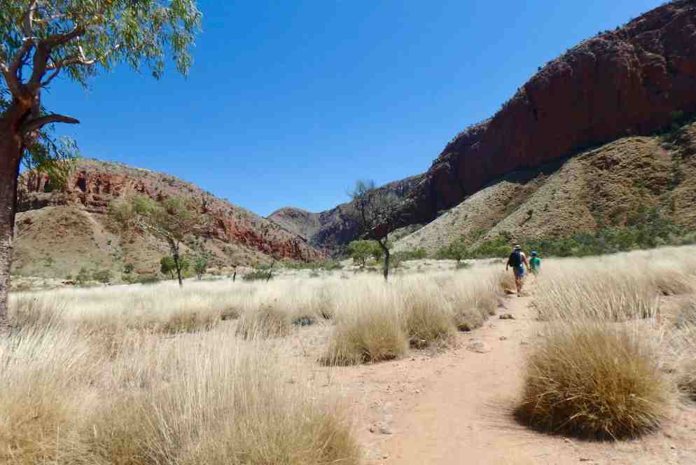
After getting a couple liters of water, we headed to Ormiston Gorge and opted to take “The Pound” hike. I was curious as to why this trail was named “The Pound” and discovered “the pound” refers to the basin formed by the ring of mountains which book-end the MacDonnell range with Mt. Giles on the east and Ormiston Gorge on the west. The seven kilometer Ormiston Gorge Pound walk is a loop hike of the pound and gorge. It initially, gently climbs the lower hills, moves to a definitive pass from which the views are stunning of the pound. It descends onto the flat floor of the pound, and returns up the dry riverbed to the main waterhole.The rugged gorge walls of red, sunburnt orange and deep purples and the Ghost Gums growing up along the ridges and walls of quartzite and the layered rock formation along the river bed were quite beautiful.

In the early section of the hike the trail was flat, meandered along the road and a dry river bed with spare vegetation. I was beginning to think this hike would pale in comparison to the last ones we had done in Uluru and Kings Canyon. But it slowly began to climb hills, with several switchbacks and the tan sands giving way to red rock and ridges, until we were heading towards a saddle.

It was quite a scene to reach the saddle and see the expansive pound fanning out below. It clearly was a panoramic view of a basin surrounded by ridges and hills.

The trail led down into the pound and at that point we encountered sandy beaches of mostly dry riverbeds, though there was one small water hole. It was a good stopping point for lunch which was accompanied by an annoying chorus of buzzing flies. I donned my net and found a way to sneak food into my mouth without letting flies in. Thankfully, when on the move the flies were tolerable and a very minimal nuisance.


This well defined trail crossed the pound and was a combination of soft and harder packed sand, tussock grasses and other desert shrubs, interspersed with a variety of rocks. I was fearful that it would be a heavy slog through soft sand in the early afternoon sun. We crossed the dry sandy rocky Ormiston Creek bed at least 3 times due to it’s looping course.and at the third crossing it seemed like the rocks were increasing and multiplying exponentially. In retrospect I found the sand easier walking than the rocks that loomed in front of me.

OLYMPUS DIGITAL CAMERA

The trail gets harder as you get closer to the Gorge. Soon we were scrambling, trudging, rock hopping, even stumbling further up the riverbed into the gorge from the pound. Sandy stretches, gave way to massive cubist like rock formations interspersed with enough moderate sized rocks to for us to engage in some “creative dance” to keep moving ahead. At points the trail was all boulders and rocks. River rocks coupled with the rust red walls, greenery and the layered formation of the gorges made for a spectacular scenery and I marveled at the array of colors of the rocks and boulders which spanned from the red and orange palette of colors and moved into many shades of mauve, purple and blue.

Sand clinging to the bottom of my hiking boots and loose sand on the surfaces of the rocks made a potentially hazardous combination and I caught myself slipping and falling on three occasions. Negotiating the rocks with beautiful scenery continuing to unfold the higher we climbed into the gorge was challenging but quite the feeling of accomplishment. Eventually we came upon a lovely oasis – a water holes in which a few young men were swimming. Since there was quite a sheet of brilliant green algae on portions of the surface of the water, I could not imagine diving in.

But after crossing to the left side of the water hole and rounding another bend not too much further up, we cam upon a much larger permanent water hole which was exceptionally inviting and was hosting several swimmers. It was just too much for us to be viewing a beautiful water hole with a magnificent backdrop and not immerse ourselves – so we doffed our shoes and jumped in in our clothes with a definite very loud yelp, proclaiming the water to be extremely chilly. But a chill after hot was a great feeling and a very refreshing finale for moderately difficult hike. And, off course the reward of cokes and/or ice-cream from the small concession at the end was definitely a plus.

It was time to get on the road, back to Alice Springs but first a stop at the ochre pits. They consisted of delicate colorful cliffs made up of layers of mudstone and silica in West McDonnell NP. The shades of the ochre range from crimson to yellow. The different colored layers are caused by the presence of iron oxide in varying amounts. The more iron oxide present, the darker and redder the color. These cliffs were a beautiful “canvas” of colorful curves and swirls. It was especially interesting to see knowing how the ochres play an important role in aboriginal ceremony. Though not a seemingly very popular stop I am glad we took the time  to see the ochre pits.

The next stop was our hotel, the Doubletree, and a needed re-grouping for our morning flight back to Brisbane. After many camp meals, we also opted to dine out and I suggest the Red Ochre Grill as it was one of the very few places that advertised serving bush tucker. Bush tucker, also called bush food, is any food native to Australia and used as sustenance by the original inhabitants, Kangaroo is bush food. Since up to this point I had not seen one kangaroo in the wild, I decided I would order one up on a plate in the restaurant. I ordered a kangaroo fillet chargrilled, with a shiraz glaze, served medium rare, on a roasted mushroom tartlet with a salad of maple bacon and apple. It was served beautifully and absolutely delicious and quite a welcome change from canned refried beans slithered onto a burrito, though with the gourmet touch of a slice of cheese in it. The others were not quite so adventurous with their food.  The following morning we were on a plane first to Adelaide and then on to Brisbane. Luke is very very interested in anything related to airplanes so he was in his glory filming the takeoffs and landings of a couple our flight.